|
"CoCoRaHS Hail Week" -- April 28 - May 4, 2025Welcome to our annual "CoCoRaHS Hail Week". Learn more about hail, including how to observe and report it, and how CoCoRaHS hail reports are used. - Monday: "CoCoRaHS Hail Reports: How to Measure, Report, and Submit Photos of Hail" Extra! Extra! Learn all about it!
- Tuesday: "What's happening with 'Hail Pads'?" Find out the scoop about CoCoRaHS Hail Pads.
- Wednesday: "Measuring Hail by using radar . . . and satellites!" Learn about dual-polarization radars and passive microwave satellites, and how CoCoRaHS reports help.
- Thursday: "Two new hail research projects using CoCoRaHS data." ICE-CHIP with the National Science Foundation, and SEaRCH with NASA.
- Friday: "Want to learn more?" Watch a recorded CoCoRaHS Webinar featuring an expert on hail, or dive into a research publication that cites CoCoRaHS hail data.
- Saturday/Sunday: "Submit a photo through a Condition Monitoring report" Photo Upload now available for hail and condition monitoring.
MONDAY: CoCoRaHS Hail Reports: How to Measure, Report, and Submit Photos of HailReporting hail, and photos of hail, is now easier than ever, especially with the new CoCoRaHS smartphone App, or by going to https://mobile.cocorahs.org/ on your smartphone. Standard website users will now see the photo upload feature directly on the hail report form, too. Entering hail data: If you experience hail at your location (even the small stuff) please use the CoCoRaHS hail report form found in the left-hand menu of your data entry page, or in the drop-down menu from the App (or mobile site https://mobile.cocorahs.org/). Even if you don't have much information about the hail or weren't home to know exactly when it happened, still send in a report and fill in what you know and skip the parts that you don't. NEW!! -- Tips for submitting hail photos Up to four photos can be uploaded with a max file size of 5MB each: - Safety first! Please DO NOT go outside during a hailstorm. Keep a safe distance from windows and take notes of the timing and other aspects of the event while it is happening.
- Once it is safe, try to collect a variety of stone sizes - not just the largest.
- "Look mom, no hands!" DO NOT hold the hail in your hand for the photo! Hands come in all sizes and are not a good indicator for scale.
- It's best if you can align the stones next to a ruler (or a specialized hail ruler) or other measuring device. Here is a great example with a ruler, and another one using a "hail measuring board".
Viewing hail data can be done through the "View Data" page or on our interactive map with the options set to view hail. You may choose to have a printed version of the hail report form where you can use a pen or pencil to mark things down as the storm is happening and then enter the data afterwards. You can also watch can our animation about measuring hail, but we are now prioritizing photos instead of hail pads. Learn more about what is happening with hail pads tomorrow.
TUESDAY: What is Happening with Hail Pads?Fun Fact: Hail pads are not (and never were) a requirement for submitting a CoCoRaHS hail report. When CoCoRaHS first began in 1998, "Hail Pads" (Styrofoam wrapped in aluminum foil) were a great way to study, document, and research hail, especially as a small Colorado localized project. It was an innovative way to capture the sizes and intensity of the hail that fell, especially if you weren't there to see it. At that time, it was easy to maintain consistency of the Styrofoam and aluminum foil being used, but as CoCoRaHS expanded to additional states, it became expensive to distribute, and inconvenient for volunteers to ship back to HQ for analysis. Additionally, the cost of the Styrofoam (not to mention the hard-to-find "extra heavy duty" aluminum foil) made it even more difficult to maintain. However, even now in 2025, Hail Pads can still be used, especially for scientific field campaigns (learn more about our field campaign partnerships with NASA and NSF on Thursday!) Do we still want your hail pads? YES! - Now with photo upload, you can include a photo of your hail pad directly in your report, just like this one from last week! And you can still make your own, or purchase an official one.
WEDNESDAY: Measuring Hail by Using Radar . . . and Satellites!Polarimetric (or "dual-pol") radars can detect the presence of hail more accurately than conventional NEXRAD radar. To do this, polarimetric radars transmit and receive horizontal and vertical radio waves - resulting in a ratio that helps relay the overall shape of the object. When falling, raindrops are shaped like tiny "hamburger buns", while hailstones are larger and much rounder.
Satellites detect hail by what is called "Passive Microwave Detection". Unlike radars, their instruments are detecting microwaves that scatter from ice particles, which differs from the way they scatter from liquid water. At certain frequencies, the amount of scattering can help scientists estimate the size of the hailstones.
In both cases, scientists often don't get to see what landed on the ground - which is where CoCoRaHS hail photos come in! See below for an example of how all three - satellite, radar, and ground - can be compared and studied. 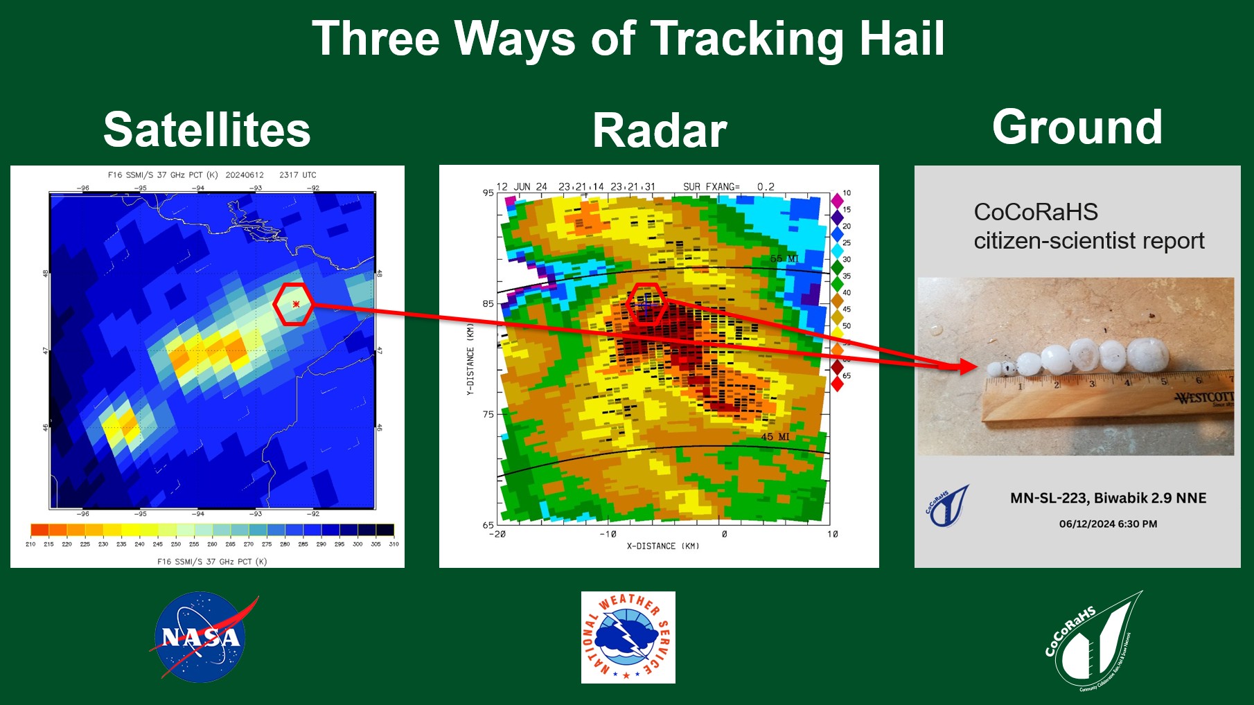
Tomorrow you can learn about two new research projects (NSF and NASA) that are partnering with CoCoRaHS!
THURSDAY: Two New Hail Research Projects using CoCoRaHS DataThis year we are fortunate to have two exciting hail observation projects going on in certain parts of the United States and you can help participate by reporting hail, even if you aren't in the specific project target areas. The National Science Foundation (NSF) has recently funded the first comprehensive hail-focused field campaign in the U.S. in over 40 years, called ICECHIP, or the In-Situ Collaborative Experiment for the Collection of Hail in the Plains. There will be a field campaign taking place over a six-week period this summer where the team will deploy mobile radars, drones, laser scanners and high-resolution cameras, and collect CoCoRaHS hail reports (and photos) with a goal of improving risk mitigation strategies while focusing on education and collaboration. Click on the ICECHIP logo below to view the project page for more. NASA SEaRCH (Southeast Region CoCoRaHS Hail) is also researching hail this summer. Using satellites, NASA scientists will detect hail in the clouds and compare them with reports (and photos) from the ground. The goal is to improve our ability to predict where and when damaging hail is expected to fall. There will be more information about this project focused on the Southeast United States in the coming months. How can you get involved? You already are! Make sure to submit a hail report (and photos) if you experience a hail event and your data will be helping more scientists than ever before!  
FRIDAY: Want to learn more?Previous CoCoRaHS "WxTalk Webinars" related to hail: Published research using CoCoRaHS hail data:
SATURDAY/SUNDAY: Submit a photo with a Condition Monitoring reportFor the first time, photo upload is now available for Condition Monitoring Reports! CoCoRaHS Condition Monitoring reports are a valuable resource for U.S. Drought Monitor authors, agriculture, natural resource managers, and others. These are pretty easy to do, and our saying is, "Once per week, is all we seek!". They don't (and shouldn't) need to be done every day. We recommend submitting on Saturday or Sunday so that they are available for input into the Drought Monitor on Monday, but if not the weekend, pick a day that works for you and stick with it. They are most valuable when you can submit on a regular basis (weekly) so that users can see the changes occurring. The idea behind these is to describe the general moisture conditions at your location and the impacts, whether it be too dry or too wet. It may be helpful to view other Condition Monitoring reports to get an idea of what other people report. If you've never submitted one, try sharing what is going on in the environment around you with a few sentences and now up to four photos! The photo upload section is just beneath the observation notes. Be sure to check the Photo Tips for help on what and how to photograph for Condition Monitoring. Learn more in our new blog post about how you and Kenny Rogers can tell us "...what condition your condition is in"! 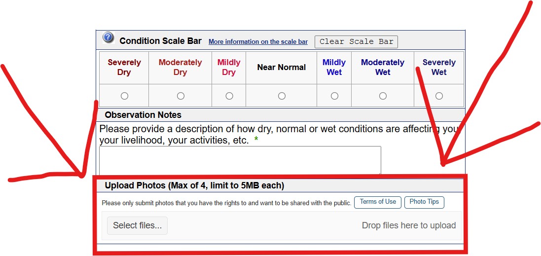
|